


BY: Lon Tegels
MONTICELLO, Arkansas — The University of Arkansas-Monticello’s “Top Gun” is putting his piloting skills to use to assess the health of the campus forest.
Dr. Hamdi Zurqani, assistant professor of geospatial science, joined the UAM College of Forestry, Agriculture and Natural Resources (CFANR) in the fall of 2021.
“Drones have recently become an essential tool for forest management and forest health monitoring,” he said. “So, we purchased this drone to help us get accurate data for every tree in our forests.”
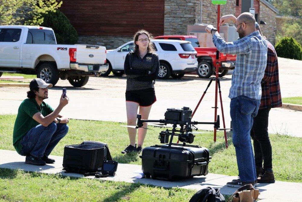
UAM flies a DJI Matrice 300 RTX — a $60,000 tool — to assess conditions the university’s 1,080 acres of forest. The drone has a flight time of about 45 to 55 minutes depending on whether it carries a payload. Its has thermal, zoom, wide-angle and distance finder capabilities.
“This drone will be utilized to characterize key indicators of urban forest health and investigate statistical relationships between forest health, such as individual forest trees and species, and vegetation indices derived from the drone imagery,” said Zurqani. “It will also be utilized to calculate the trees’ heights and crown widths and use this information to calculate how much carbon is held in its above-ground biomass.”
Fast-developing technology
“Drone-based remote sensing is one of the fastest-developing suites of technologies, with high impacts on improving the accuracy and efficiency of managing natural resources and agricultural operations,” said CFANR Dean Michael Blazier. “We’re very fortunate in our College to have a professor of Dr. Zurqani’s caliber to lead the way for us in this field. He has a robust research program underway for advancing the capabilities of drone-based remote sensing, and our graduate and undergraduate students benefit greatly from how he is incorporating his leading-edge work into the classroom.”
Learning to fly
Talk to Zurqani about his measurement tool and he can provide you with a lot of information very quickly.
Equipped with sensors that can read visible light and near-infrared bands, “this drone can be used to monitor forest health and detect early signs of stress,” Zurqani said. “Also, with the LiDAR system, we can obtain fine-resolution 3-D data on forest structure.”
LiDAR stands for light detection and ranging. It is a remote sensing method that uses a pulsed laser to measure range and generate precise 3-D data. The LiDAR system UAM purchased comes with eight lasers. The LiDAR software and data package can process and convert the measurements into maps and graphics.
Before Zurqani could use the drone and its data collection, he and three students went to Alabama for training on the LiDAR system. UAM students on the training mission were AlSaket AlDaikh, Ricky Parris, and Katie Hickle.
To use the drone, Zurqani had to be certified by the Federal Aviation Administration. Zurqani says students will be tested and receive their remote pilot certificate issued by the Federal Aviation Administration before being allowed to fly.
Centimeter precision
For the drone to make the most of the drone’s precision tools, UAM needed a base station.
The base station is known as a Global Navigation Satellite System, or GNSS. The GNSS receiver collects GPS measurements at a known location. GNSS receivers like those in smartphones can only determine the position with two to four meter accuracy, meaning that if you use your smartphone to navigate to a point you would be able to get within 10 to 13 feet of the point. However, the UAM base station, which includes a GNSS correction technology, means “we could obtain high-precision positioning data at centimeter-level accuracy,” said Zurqani. As such, navigating using the UAM base station you would be able to get to within an inch of the point you are targeting.
About the College of Forestry, Agriculture and Natural Resources and the Arkansas Forest Resources Center
The College of Forestry, Agriculture and Natural Resources, and the Arkansas Forest Resources Center, a University of Arkansas System Center of Excellence, brings together interdisciplinary expertise through a partnership between the University of Arkansas at Monticello and the University of Arkansas System Division of Agriculture. The College and Center are headquartered at the University of Arkansas at Monticello campus, but their programs range statewide with the mission of developing and delivering teaching, research, and extension programs that enhance and ensure the sustainability and productivity of forest-based natural resources and agricultural systems. Academic programs are delivered by the College of Forestry, Agriculture, and Natural Resources through the University of Arkansas at Monticello. Through the University of Arkansas System Division of Agriculture, research is administered by the Arkansas Agricultural Experiment Station, and extension and outreach activities are coordinated by the Arkansas Cooperative Extension Service